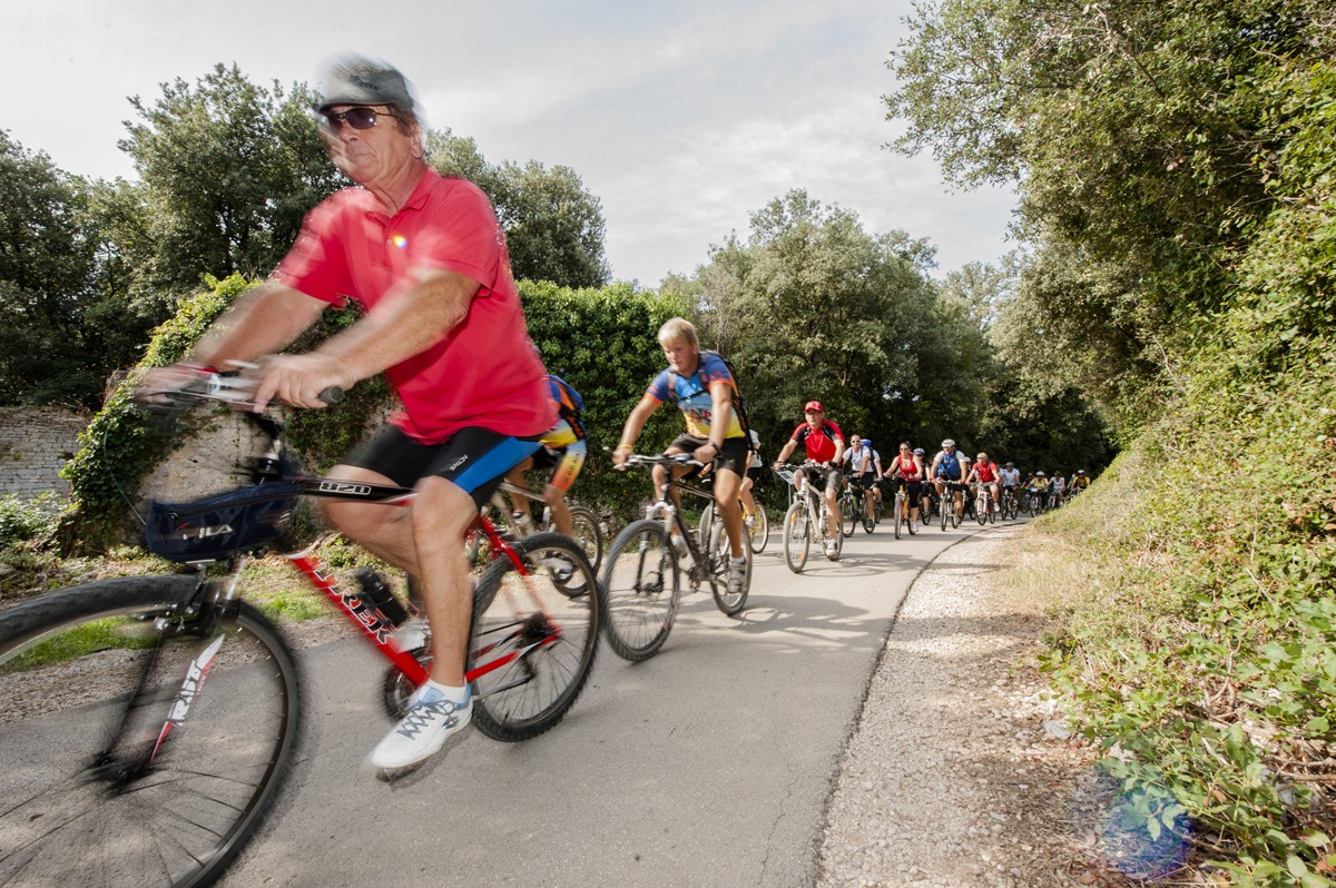
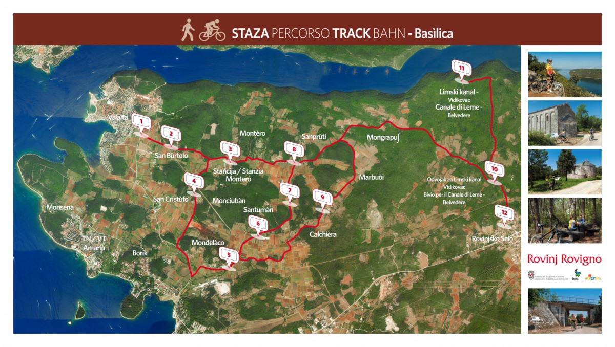
Track Basìlica
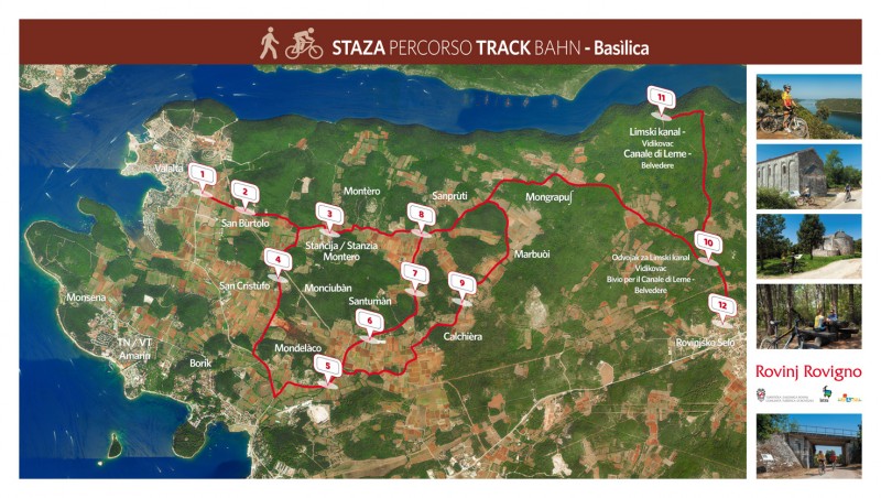
Technical characteristics:
Total length of the path: 18,7 km
Start/finish point: Valalta / Rovinjsko Selo
Technical difficulty: Easy
Highest point: Rovinjsko Selo (151 m)
Lowest point: Mondelàco (8 m)
Driving time: 1,5 h (in one direction)
Walking time: 2-3 h (in one direction)
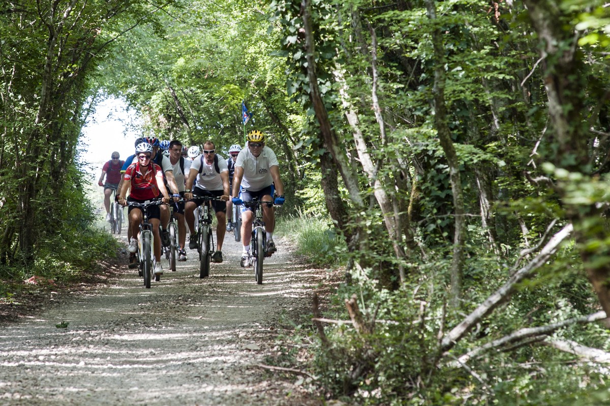
Terrain: mixed
- asphalt: 7,6 km
- macadam: 10,4 km
- field road: 700 m
Points of interest
1. BASÌLICA VALLEY(toponym)
The spacious Basìlica valley stretches southwards from the first section of this path. Local legend says that it was named so because part of the land of that spacious valley was owned by the Rovinj Church of St. Anthony of Padua, thanks to a donation by the family of Domenico Lorenzetto. His wife was allegedly cured after visiting the Paduan Basilica of St. Anthony. For that reason, the married couple later built a “basilica” in Rovinj, i.e. the mentioned Church of St. Anthony of Padua (situated in the square bearing the same name in front of the present-day “Calisona” Restaurant; the church was torn down in 1933). The agricultural estates found in the northern part of the rural area of Rovinj were therefore called 'the basilica estates'.
- The Basìlica valley is one of the larger and more significant agricultural complexes in the Rovinj area, with vineyards, olive groves, orchards (especially figs, cherries, pears, quinces, gooseberries, peaches, almonds, hazelnuts, walnuts, etc.) and other agricultural cultures typical of the region.
- Some of the nearby hills abound in high Mediterranean macchia, prehistoric forts and interesting historic archaeological sights.
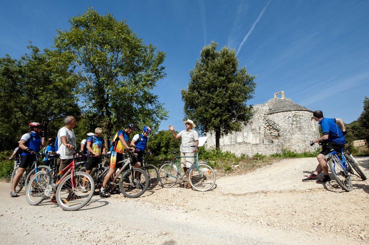
2. CHURCH OF ST. BARTHOLOMEW (ST. BARTOL) THE APOSTLE (Locality: San Bùrtolo/toponym/)
The church is situated in the northern rural area of Rovinj, on the edge of a fertile valley, at the foot of the hill bearing the same name. It is one of the larger one-nave Romanic field churches in Rovinj. The interior of the church is distinguished by a wooden transenna horizontally dividing the section for women and the section for men. The altar painting presented St. Bartholomew, the titular of the altar and the church, as well as St. George and St. Euphemia, the patron saints of Rovinj.
- The church was one of the places the pilgrims used to visit on the second day of processions of the Ascensionsus when all Rovinj field churches were visited and people socialized and prayed for the crops.
- ST. BARTHOLOMEW (celebrated on August 24; patronymic = Son of Talmai; his personal name: Natanaele) was one of the 12 apostles. Jesus considered him 'a true child of Israel with no duplicity in him', a fair and honest person. After he managed to convert numerous people, he was skinned alive and decapitated by barbarians. For that reason, he became the patron saint of skinners. His symbols include a cape showing his own skin and a knife.
3. “MONTÈRO” AGRO-TOURIST ESTATE
Locality: Montèro (toponym)
This agro-tourist estate is situated in a rural homestead (locally: stancija) bearing the same name, in a lowland area between the Monciubàn hill in the south and the Montèro hill in the north.
- As a historic architectural category, rural homesteads locally known as stancije are particularly characteristic of southern and western Istria. Just as any other, Stancija Montèro (dating from the 19th century) represents both an architectural and an agricultural complex. It has all the elements of rural architecture and its residential units are centered around an open yard that is used, just like most of the other buildings, for agricultural purposes.
- The locality and the agro-tourist estate were both named after the hill bearing the same name (situated at 125 asl; with one of the highest hilltops in the Rovinj rural area) that stretches north of Stancija Montèro and preserves remnants of the walls of a large pre-historic fort.
- Some of the nearby hills abound in high Mediterranean macchia, prehistoric forts and interesting historic archaeological sights.
4. CHURCH OF ST. CHRISTOPHER (Locality: San Cristùfo /toponym/)
This church in one of the more significant Romanic one-nave field churches in Istria not only due to its location on the edge of the fertile Basilìca valley (top.) on a slightly elevated terrain (the church lies on a live rock) with a view towards south stretching to the church and the bell-tower of St. Euphemia, but also due to its distinct lateral façades enlivened by the motif of lesenes ending with blind arches (6). The small protruding apse is covered with limestone plates (locally: škrilje). Along with the images of St. Francis of Assisi and St. Elijah the Prophet, the altar painting also presented St. Christopher the Titular. Until 1869, the church portal included an architrave with two lions and four animal heads on a rustic bas relief. The church was desecrated a long time ago and last restored in 2000.
- The church was one of the places the pilgrims used to visit on the second day of processions of the Ascensionsus when all Rovinj field churches were visited and people socialized and prayed for the crops.
- ST. CHRISTOPHER (celebrated on July 25) was persecuted by Emperor Decius (middle of the 3rd century). He was shot dead by arrows and decapitated. One of the numerous legends says that Christopher (meaning of the name: “Christ-bearer”; called Reprobus prior to being converted) was entrusted, due to his strength, with the task of carrying the pilgrims over the river. He thus also carried a child who turned out to be Jesus Christ, so heavy that his back bended. To prove he was Jesus Christ, the child told Christopher to plant his palm stick in the ground and it would grow, which really happened the following day. St. Christopher thus became the patron saint of travelers, pilgrims and sailors. His main symbols include Jesus Christ – the child on his shoulders - and the stick.
5. THE FIRST TUMBÌN – MONDELÀCO QUARRY (Locality: Mondelàco /toponym)
We are in front of the so-called First Tumbìn (top.), the overpass of the old Kanfanar-Rovinj railroad track (section of the Trieste – Pula track) completed in 1876. The track has not been used since 1966. Today it is an example of industrial/railroad archaeology. To be more precise, along several long sections of the Rovinj part of the mentioned track, such as the one that crossed the “first tumbìn”, a relatively well-filled layer of crushed stone, a railroad tie and rails have been preserved, bearing witness to this high-value product of Austrian railroad civil engineering.
- The leftward path leads to the Mondelàco quarry, abandoned a long time ago, situated on the slope of the hill bearing the same name. It was one of the numerous Rovinj quarries that were opened along the coast and in the inland during the Roman period, and especially during the time of the Venetian Republic. The excavation and processing of stone used to be the main economic activities in Rovinj. Different types of stone were excavated but mainly the Istrian Biancone (a type of Teutonic limestone from Upper Jurassic Period) that was used to build numerous buildings, waterfronts, churches, bridges and other structures in Venice and some other towns in the Veneto, Romagna and Marche regions. The image of Rovinj stonecutters “skillfully crushing stone with /like/ wood” is still very much alive.
- The toponym Mondelàco denotes that a water-filled depression (italian dialect: làco) used to be situated in its vicinity. In the past, such depressions were quite numerous and characteristic of the Rovinj field landscape.
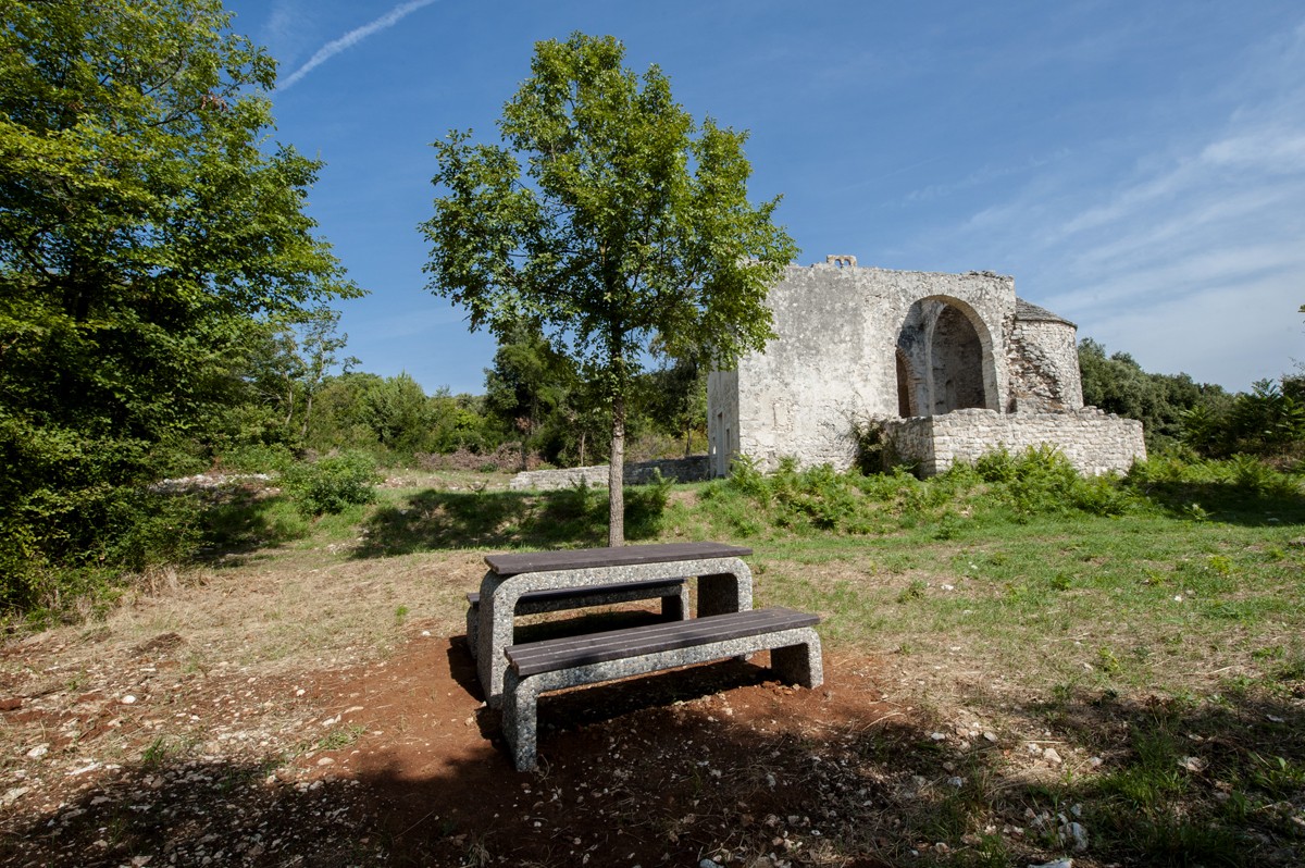
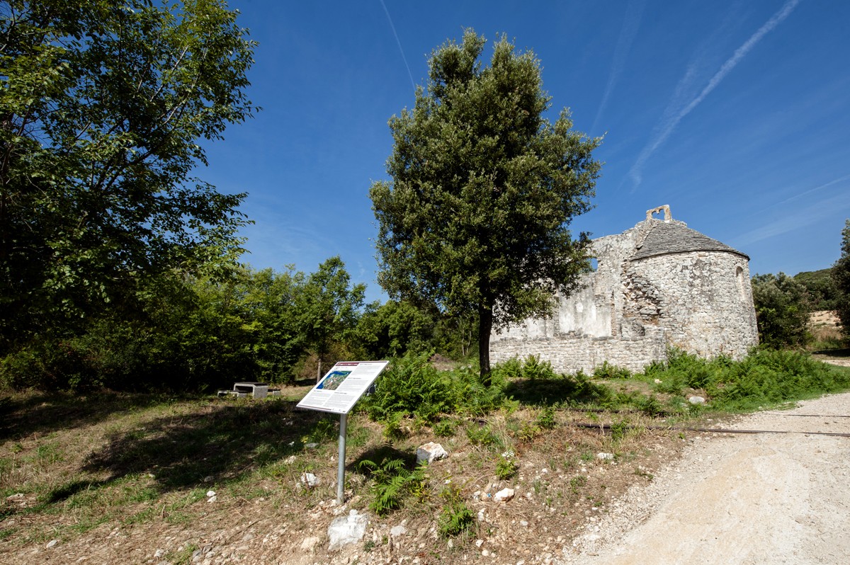
6. CHURCH OF ST. THOMAS THE APOSTLE (Locality: Santumàn /toponym/)
Situated at the foot of the hill bearing the same name, this church is one of the most significant Istrian field churches. We are speaking about a pre-Romanic building from 8 - 9 century. The original building had a cross-shaped ground plan with three protruding apses covered with limestone plates (locally: škrilje). The mere crossing was elevated and connected with its lateral arms by way of openings of the semicircular arches. There was a rectangular structure over the central section. The bell-tower of the church is exceptionally rare, annexed during the medieval period alongside the northern wall. During the 16th century, the church was reduced to a one-nave space and cut short on its western side. The excavations disclosed the original paving of the northern arm of the crossing and several fragments of the window transenna and the altar partition (pluteuses, beams and capitals). The altar painting presented the resurrected Redeemer and St. Thomas.
- The church was one of the places the pilgrims used to visit on the second day of processions of the Ascensionsus when all Rovinj field churches were visited and people socialized and prayed for the crops.
- ST. THOMAS (on July 3) is one of the 12 apostles. He was tortured and buried in Malipur in 72 AD. The most famous legend says that the “doubting“ Thomas was doubtful of the ascension of Jesus Christ and requested to touch his wound to be personally convinced. He is the patron of land-surveyors, architects, masons and others. His main symbols included the protractor, spear and belt.
- The remnants of the nearby abandoned Kanfanar-Rovinj railroad track (used from 1876 until 1966), are today an example of industrial/railroad archaeology.
7. THE SECOND TUMBÌN (Locality: Àrbi da S. Ufièmia /toponym/)
We are in front of the so-called “Second Tumbìn” (top.), the overpass of the old Kanfanar-Rovinj railroad track (section of the Trieste – Pula track) completed in 1876. The track has not been used since 1966. Today it is an example of industrial/railroad archaeology.
- To be more precise, along several long sections of the Rovinj part of the mentioned track, such as the one that crossed the “second tumbìn” (overpass), a relatively well-filled layer of crushed stone, a railroad tie and rails have been preserved bearing witness to this high-value product of Austrian railroad civil engineering.
- The railroad route, elevated at some points by 1 or 3 meters in relation to the nearby terrain, ensures a panoramic view of the surrounding bays and hills, whose floristic landscape is characterized by Mediterranean maquis and English oak, Turkey oak, holm oak, ash, elm, hornbeam, European cornel, spruce, chestnut, strawberry tree, and various types of bushes. Asparagus plants grow in the spring, and mushrooms in the fall.
- The trenches along the road that leads in both directions from the “Second tumbìn”serve today, as they did in the past, to channel the precipitation water in order to avoid floods in the fields and road damage, thus enabling the filling of depressions and wells.
8. CHURCH OF ST. PROTUS THE MARTYR (Locality: Sanprùti /toponym/)
It belongs to the group of smaller one-nave Early-Gothic field churches. Along with its titular, the altar painting presented numerous other saints (among which also St. George and St. Euphemia, the patron saints of Rovinj). It was abandoned at the end of the 18th century and deteriorated during the following several decades.
- The church was one of the places the pilgrims used to visit on the second day of processions of the Ascensionsus when all Rovinj field churches were visited and people socialized and prayed for the crops.
- ST. PROTUS (celebrated on September 11; meaning of the name: “The First”) was a martyr from the 3rd century often worshipped together with his brother St. Hyacinth. The legend says that the brothers were eunuchs and slaves of a Roman noblewoman called Eugenia whose fiancé had them tortured because they had allegedly converted her. Protus, whose main symbol is the palm, is presented wearing a beard, whereas Hyacinth is presented beardless.
- Continuing towards northeast, along a white path, we arrive behind the hills stretching above the southern shore of the Lim Channel towards Rovinjsko Selo.
9. THE “HABER” RIDING CENTER
The “Haber” Riding Center and Geno Park has been breeding Trakehner horses and Spanish horses and ponies for over 30 years with a decade of experience. The riding school (FN – registered riding school) is run by an expert instructor (FEI – trainer).
At the farm, aside from the riding school, it is also possible to train horses for all equestrian sports categories as well as to tame wild horses and correct the behavior of traumatized horses. The school operates within the “Saint Euphemia” Equestrian Club, whose riders very successfully partake in training and hurdle competitions of the highest difficulty. The equestrian club’s training takes place at a riding hall with special groundwork.
For riding on a terrain in nature there are a series of different trails of various lengths that are appropriate for all categories and all age groups of riders.
Along with horse breeding and the riding school at the farm, indigenous Croatian animals are also bred here with the goal of opening a Geno Park. Istrian oxen and donkeys, the Posavina horse and indigenous dog breeds (the Tornjak and the Croatian Sheepdog) are bred on the farm as well.
11. VIEW SPOT ABOVE THE LIM CHANNEL (Locality: Finìda /toponym/)
This natural view spot found at 80 m asl towers over the part of the southern shore of the Lim Channel called Pònta dei Frati (top. = Friars' Cape). The beauty of the landscape surrounding the View Spot is enriched by the distinct beauty of the Lim Channel enjoying the status of a special sea reserve and a significant landscape.
We are speaking of a 12 km long sea bay that is approx. 600 m wide at its entrance and 33 m deep. Lim Channelrepresents a sunken karst valley (during the iceberg melting phases) of the former paleo river called Pazinčica, formed in Jurassic limestones, that later became an underground river (which sank in the Pazin cave), while its last part (present-day Lim Walley and Lim Channel) dried out. The name of this sea bay is ascribed to the fact that during Roman times it represented limes, i.e. the boundary between the Pula and Poreč state properties.
- The diversity of deciduous vegetation of the southern and evergreen vegetation of the northern slopes of the bay represents a true rarity and a special ecological phenomenon.
- The view from the View Spot stretches towards east to the last section of the Lim Channel, on the opposite side to its northern part preserving remnants of the old Benedictine Monastery of St. Michael above Lim (abandoned a long time ago), and towards west to its entrance and the open sea.
- During Roman times, the medieval period and especially during the time of the Venetian Republic, various types of stone were excavated from the numerous quarries found in the Lim Channel, mainly the Istrian Biancone stone (a type of Teutonic limestone from Upper Jurassic Period) that was used to build numerous buildings, waterfronts, churches and other structures in Venice and some other towns in the Veneto, Romagna and Marche regions. The image of Rovinj stonecutters “skillfully crushing stone with /like/ wood” is still very much alive.
12. ROVINJSKO SELO (toponym)
Rovinjsko Selo (145 m asl) is one of the communities within the town of Rovinj (only 7 km away). The surrounding area was inhabited during the pre-historic and Roman times and hence abounds in archaeological sites (forts; rustic villas). Rovinjsko selo was established in 1526 by Dalmatian immigrants (from the surroundings of Zadar), who were fleeing from the Turks, with consent of both Venetian and Rovinj authorities.
The old center of the village has been preserved (situated in the central part of the present-day village, in the Lakuverča locality). It includes interesting and distinct rural architectural elements, i.e. residential/commercial complexes with yards, built wells and terraces with staircases (locally: baladuri). The parish church (also the cemetery chapel) is dedicated to St. Anthony the Abbot. It is a one-nave building with straight back part and a baptistery.
Some of the nearby hills abound in high Mediterranean maquis, prehistoric forts and interesting historic archaeological sights.
Rovinjsko Selo fosters a rich folklore and carnival tradition, old customs and habits (associated mainly with rural civilization), as well as the “balun”, a typical Istrian dance with an interesting variant in Rovinjsko Selo. An event called “Antonja”, an exhibition of wine and olive oil, is held on St. Anthony the Abbot's Day (January 17).